

-SEB%20CREDIT%20MarshallIslandsPocketGuide.com.webp?v=2026-07-09T18%3A30%3A56.459Z)
A Self-Drive (or Cycle) Day Tour of Majuro
Looking for the ultimate self-guided day trip around Majuro? This one-day itinerary follows Lagoon Road from Delap to Laura Beach, passing colourful murals, historic wells, roadside snack stalls, snorkelling spots, peaceful villages and some of the most scenic stretches of Majuro Atoll.
The route works on any day of the week. Sunday brings church singing and plenty of local atmosphere, while weekdays give you a better chance of finding handicraft shops and other stops open along the way.
Rent a car, scooter or bicycle, pack your swimming gear and leave plenty of room for spontaneous stops. By the time you reach Laura Beach, you will have seen much more than the destination itself, which is exactly what a good Majuro road trip should be about.
Note that this is a one-way itinerary, so factor in the return journey, especially if you're travelling by bike.
This article is based on real on-the-ground research, not on AI scraping old content from the internet. Learn how we use AI!
Table of Contents
How to Get Around Majuro Using This Self-Guided Itinerary
This self-guided one-day itinerary takes you from Marshall Islands Resort in Delap to Laura Beach. To follow the route independently, you will need to rent a car, scooter or bicycle. Tips on where to hire vehicles can be found in the following guides:
- 5 Best Car Rentals in Majuro & the Marshall Islands
- Scooter Hire in the Marshall Islands: Where to Rent, Cost & More
- The Ultimate Guide to Cycling in the Marshall Islands
For more transport options, check out the Majuro Transport Guide: 15 Ways to Get to (& Around) Majuro.
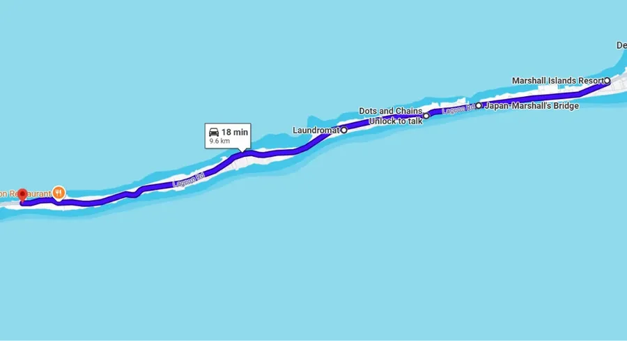
Marshall Islands Resort to Iakwe Katoj Park
Distance: 6 mi (9.6 km), Drive time: 18 mins, Cycle time: 50 mins.
Marshall Islands Resort and Road Trip Snacks
For the purposes of this itinerary, start at Marshall Islands Resort in Delap, the westernmost accommodation in town and a convenient place to begin travelling west.
Pick up coffee, freshly baked bread or a made-to-order sandwich from Annie’s Bakery. Alternatively, check the Local Market outside the resort for seasonal fruit, banana chips, breadfruit chips and other homemade snacks sold by women from Laura.
Annie’s Bakery is open Monday to Saturday, while the Local Market usually operates from around 9 am to 5 pm Monday to Friday. For a Sunday road trip, stock up the day before.
Majuro Bridge
Follow Lagoon Road west for approximately 1.2 mi (2 km) to reach Majuro Bridge. Peer over the side to see the clear channel below or cast a line if fishing is your thing, as the moving water makes this a popular local fishing spot.
Walk towards the centre of the bridge and you will technically be standing at one of the highest elevations reached during a road trip around Majuro. No crampons required.
Continue another 0.6 mi (900 m) to the JoeMar Development Ltd. Billfish Mural, a bold roadside artwork featuring a colourful, well, billfish.
It is an easy photo stop before continuing west. Find more public artwork in the Majuro Street Art Guide: 5 Murals to Find in Majuro.
Kin Iokwe Rentals and Mt Trashmore
Another 0.8 mi (1.3 km) along the road brings you to Kin Iokwe Rentals. This is where you can collect a bicycle or scooter if you have not arranged delivery to your accommodation.
The company also rents snorkelling equipment, kayaks and paddleboards, which may come in handy for later stops along the route. Payments are cash only.
Right next door is Mt Trashmore, Majuro’s rather honestly named landfill. It is not a conventional attraction, but it offers a striking reminder of the challenges involved in managing waste on an atoll where spare land is practically mythical. Roll up your windows...
Rairok and Iakwe Katoj Park
As you continue through Rairok, stop at K&K Island Pride Long Island if you still need drinking water, picnic supplies or proper groceries. This is one of your last convenient opportunities for a full supermarket shop before heading farther west.
Buildings gradually become more spread out beyond this point and the busy atmosphere of town begins to fade. The road feels quieter, the lagoon seems closer and the sense of peace becomes increasingly noticeable.
Continue another 3.4 mi (5.4 km) to Iakwe Katoj Park, a free waterfront park near the western end of the airport runway. Stretch your legs, check out the reef or let younger travellers loose on the playground before beginning the next section of the journey.
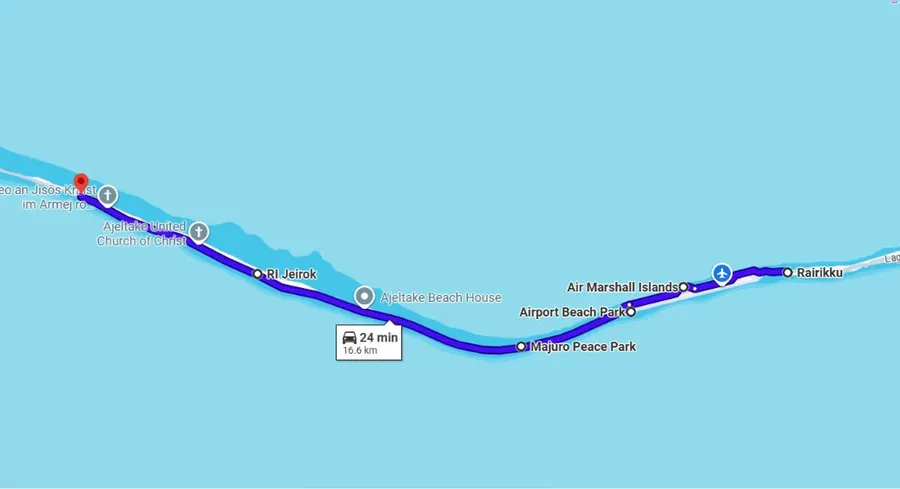
Iakwe Katoj Park to Yummy’s Food Truck
Distance: 10.3 mi (16.6 km), Drive time: 25 mins, Cycle time: 1 hr 25 mins.
Airport Snorkelling Spot
From Iakwe Katoj Park, continue west along Lagoon Road beside the airport runway for approximately 1.6 mi (2.5 km). Park near the hangar car park and cross the road to reach the Airport Snorkelling Spot.
The unlikely location hides large fan corals, reef fish and clear lagoon water. The nearby lagoon-side beaches are also popular for fishing, so bring a rod as well as a mask and snorkel if that is your thing.
Check out The Best Snorkelling in Majuro: Top 5 Places to Snorkel to learn more about it.
Airport Beach Park
Continue another 0.8 mi (1.3 km) to Airport Beach Park, at the western end of the runway.
The park’s main feature is a deep saltwater pool cut into the reef, originally created as part of land-reclamation work. It is deep enough for swimming, with the odd fish inside, while picnic shelters make it an easy place to pause.
From here, the road crosses one of Majuro’s narrowest stretches, with the lagoon on one side and the Pacific Ocean on the other.
Japanese Peace Park
After another 1.6 mi (2.6 km), stop at the Japanese Peace Park.
The Japanese government constructed the memorial in 1984 to honour those who lost their lives in the East Pacific during World War Two. Some of Majuro’s largest surviving trees shade the memorial and concrete seating area, making this a peaceful place for a short break.
Find more stops like these in the 20 Free & Cheap Things to Do on Majuro.
Ajeltake and 17 Mile
The road becomes greener beyond the park, passing coconut palms, shaded stretches and quiet weto communities. This is one of the most enjoyable parts of the route for cyclists, with considerably more shade than the exposed airport section.
After approximately 3.7 mi (6 km), around Ajeltake Elementary School, you will reach the area locals call 17 Mile, roughly the halfway point between town and Laura Beach.
Jikin Keepep Eṇ
Around 820 yards (750 m) beyond 17 Mile, look for the roadside mural marking Jikin Keepep Eṇ.
It tells the legend of the giant Tōl̗tōl̗ipāān, whose enormous footprint is said to have pressed into the earth and raised the surrounding land. The dunes associated with the story are on private property, but the mural and interpretation panel are easy to view from the roadside.
Learn more in 10 Best Historical Sites in the Marshall Islands.
Yummy’s Food Truck
Continue through Ajeltake, passing small churches that come alive with singing on Sundays. There is also a petrol station along the way if you need to refuel.
Another petrol station appears approximately 2.6 mi (4.2 km) farther west, close to Yummy’s Food Truck. It is worth remembering for the return journey if you are feeling peckish, and it's even open on a Sunday.
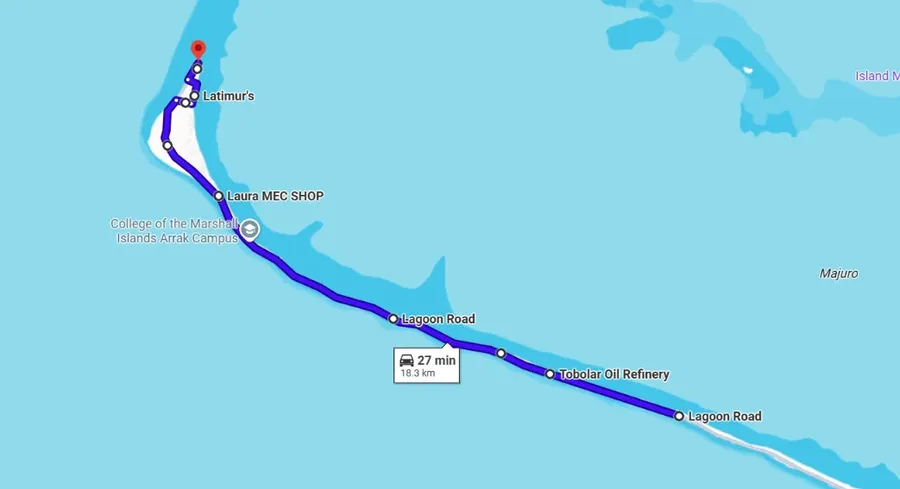
Yummy’s Food Truck to Laura Beach
Distance: 11.4 mi (18.3 km), Drive time: 27 mins, Cycle time: 1 hr 35 mins.
HNR Letora Handicraft and Tobolar Coconut Oil Refinery
Continue west to HNR Letora Handicraft, proof that excellent Marshallese crafts are not confined to town. The shop opens throughout the day Monday to Saturday but closes at 9 am Sunday, so Sunday travellers will need an early start.
You will also pass the Tobolar Coconut Oil Refinery. Some guides can arrange visits here, although the main factory tour takes place in town. Learn more in 30 Best Things to Do on Majuro.
LiModrel’s Well
Continue approximately 3 mi (4.8 km) to LiModrel’s Well. Look carefully for the small metal plaque on the right-hand, lagoon side of the road.
The well is associated with Majuro’s recovery after the destructive 1905 typhoon, when a freshwater source was discovered after birds were seen drinking from a small hole.
Jikin Jekjek Wa Eṇ
Another 1.8 mi (2.9 km) brings you to Jikin Jekjek Wa Eṇ, also on the lagoon side.
The site marks where the legendary trickster Ļetao is said to have carved his outrigger canoes. An interpretation sign tells the story, making this an easy cultural stop before Laura.
Laura Village and School Murals
Continue approximately 3.4 mi (5.5 km) until you reach the sign and fork for Laura Village. Take the ocean-side road to pass Laura School, where colourful murals decorate the roadside walls.
See more artwork in the Majuro Street Art Guide: 5 Murals to Find in Majuro.
After passing the Salvation Army, cut back towards the lagoon side and continue past Laura Ball Field. You may catch a baseball or softball game if your timing is right.
Typhoon Memorial and Bōkjānwūt
Rejoin Lagoon Road and continue approximately 240 yards (220 m) to the Typhoon Memorial, commemorating those lost during Majuro’s devastating early-20th-century storms.
Follow the road to Laura Beach, pay the entrance fee and continue inside the grounds to Bōkjānwūt. This shallow historic well is linked to the legend of a young hero who transformed his mother using a chant and coconut milk.
Read more about these cultural stops in 10 Best Historical Sites in the Marshall Islands.
Laura Beach
Finally, Laura Beach is your oyster. Swim, snorkel, walk along the sand or settle beneath the trees for the rest of the afternoon.
On the way into or out of Laura, watch for small roadside stalls selling fruit and homemade Marshallese snacks. Vendors and selections change regularly, so bring cash and stop when something looks good.
Missed a mural, plaque or snack stall on the journey west? You have the entire drive back to find it.
More About Planning a Self-Guided Day Trip on Majuro
That's it for our self-guided day trip of Majuro, including Laura Beach. For more details about the sights visited on this one-day itinerary of Majuro, these other articles should do just the trick!
- Sightseeing in Majuro: Top 10 Sights in Majuro
- 30 Best Things to Do in Majuro
- The Food Guide to Majuro: Places to Eat and Food Tours
Finally, don't miss a thing on the Marshall Islands' central island group with The Complete Travel Guide to Majuro.

-SEB%20CREDIT%20MarshallIslandsPocketGuide.com-900x326.webp?v=2026-07-22T19%3A12%3A37.340Z)